Smallworld GIS – Moving into the future with state-of-the-art technology
By utilising open technologies such as Java and PostgreSQL, Smallworld GIS heralds the next stage in its success story. Combined with its high scalability and technical expertise, it once again confirms its position as one of the most modern and best geoinformation systems in the energy, water and telecommunications sectors. Operation in the cloud creates additional benefits for network operators.
The advantages of Smallworld GIS have long been recognised: at its core lies a powerful database that effortlessly maps even the most complex network structures with millions of objects in a topologically correct manner. Version management based on the database alternative concept enables any number of users to work simultaneously and without conflict when planning, recording and updating their network data. In combination with the mature standard data models for the individual sectors, Smallworld users achieve productive results quickly. The extensive functionality of these standard modules (Smallworld NRM – Network Resource Manager and Smallworld Network Inventory) is continuously developed in collaboration with a strong user group. New customers in particular benefit from this, and the endless loops often seen in GIS implementation projects do not occur with Smallworld and the NRMs.
Another advantage is the high level of integration capability. As a result, Smallworld GIS plays a central role as the primary data repository for corporate assets within the network operators’ IT infrastructure. It integrates these assets with other business-critical applications via direct interfaces such as the Smallworld Business Integrator (SBI) or, via the Geospatial Server (GSS), through service-based integration.
Future-proof foundation for the cloud
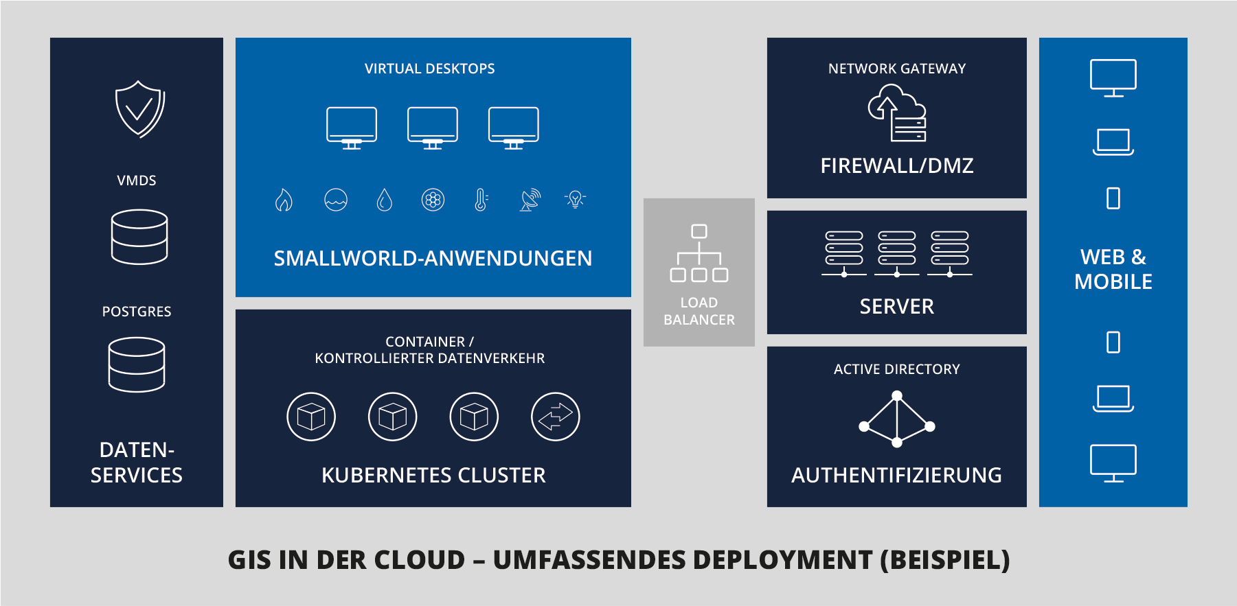
By utilising the latest Java platform, Smallworld has been meeting the requirements of a modern system architecture and high security standards for several years. With version 6.0, the Smallworld database is taken to a new, future-proof level through the optional switch to the industry standard PostgreSQL. In combination with its proven version management, Smallworld reaches another milestone and lays the groundwork for even more efficient operation of the GIS in a cloud environment, for which there is growing demand. The major advantages of the Smallworld architecture – such as scalability, performance and standard data models, which other systems offer only to a limited extent – thus also open up new possibilities for integration. For instance, Smallworld is already integrated into the GridOS platform from system manufacturer GE Vernova in an international context. This open, end-to-end system for utilities runs as a native cloud solution in a Kubernetes environment and meets the requirements of zero-trust security. The Smallworld data models, containing the captured network data, provide the foundation for numerous microservices designed to precisely support the business processes of network operators.
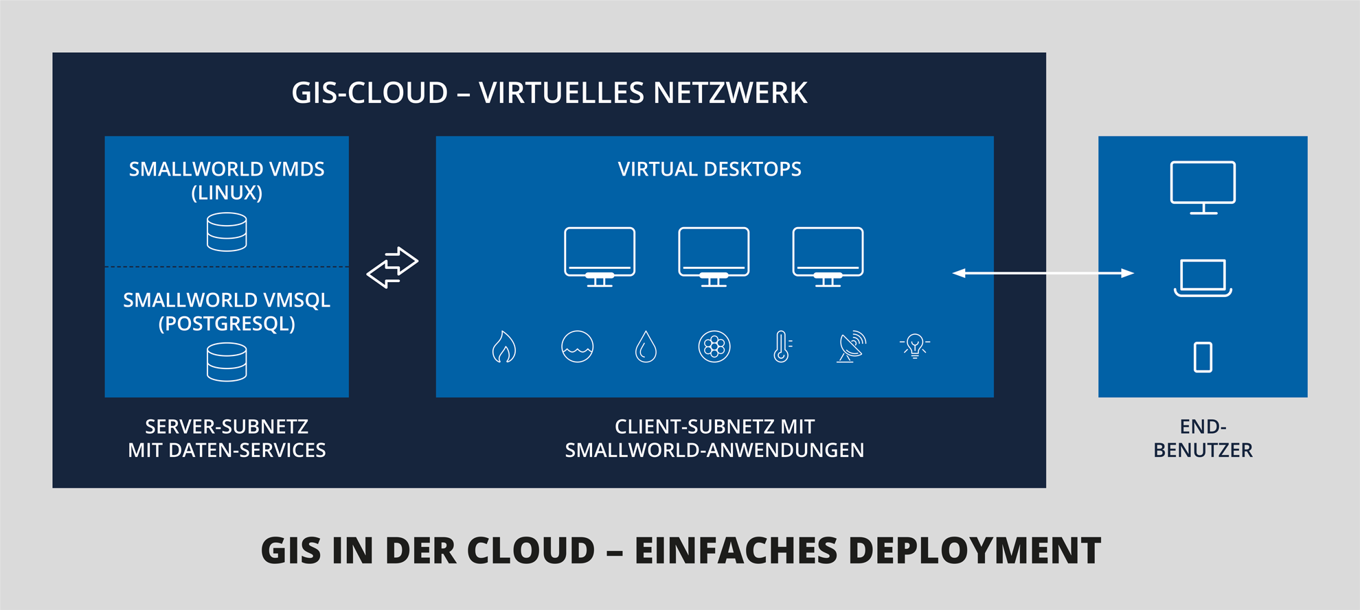
Possible components and technologies for deploying and utilising a cloud environment. The components and technologies are selected individually for each customer.
However, even with the current version 5, the Smallworld system can already be operated via a cloud provider to take advantage of the full flexibility and high availability of a cloud architecture. This includes data backup, monitoring and performance management. Behind the decision to operate a GIS in the cloud lies not only security considerations but also a key resource question: as a network operator, can I and do I want to build up my own staff to handle server maintenance, application configuration, ensuring system security, version updates and quality-assured data maintenance? Given the widespread shortage of skilled workers, this question is currently a major concern for many network operators. Companies are therefore already using Smallworld GIS today either within their in-house infrastructure, their cloud environment, or as Software-as-a-Service.
The GIS is hosted in a secure cloud environment with user management and backup services. Users log in to the cloud and launch the GIS client there. Everything takes place locally within the cloud and is therefore secure and high-performing. The GIS data is stored either in the conventional VMDS database or the new PostgreSQL database.
State-of-the-art domain data models
The partners of the Smallworld Alliance are continuously expanding the functional scope and data models of the industry-specific modules in response to current market developments and requirements from the Smallworld User Group, which has over 150 members. The resulting releases are published directly on the basis of the corresponding new Core version. Version 5.3 is currently in use, and Core with NRM Release 6.0 is scheduled for release at the end of 2025. This continuous development ensures that, alongside many other topics, changes required as part of the energy transition are made available to users quickly. These include aspects such as a comprehensive data and functional model for charging infrastructure and energy storage systems, documentation of controllable consumption devices (Section 14a EEG) or power line connectors. Added to this is the implementation of industry association requirements, such as gas/water pressure information in accordance with DIN EN 805, or the mapping of market and metering locations, as well as network locations and location bundles. Further topics include the collection of characteristic data for heat pumps, gas quality monitoring, or the extended mapping of multi-utility house connections.
Furthermore, the 3D capability of network data is becoming increasingly important in supporting core processes such as planning and network expansion in line with a BIM (Building Information Modelling) approach. The use of new augmented reality (AR) technologies also underscores its ever-growing significance. The specialist modules already provide a 3D point model for these applications, which is also being expanded in Version 6. It enables the true location to be stored in a displaced representation and, together with the Digital Terrain Model, forms the basis for the integrated 3D network display in Smallworld. In the context of drainage too, users are already benefiting from the switch in the geometry model of the Sewer module from 2½D to 3D, for example to make better use of modern solutions for process-supporting structural data modelling or to achieve the representation of a digital twin.
With the energy transition, the district heating network is also increasingly coming into focus. This is also reflected in the widely used District Heating module, which benefits from a host of new functions and enhancements in Version 6. The harmonisation of basic module structures ensures optimal support for documentation. Multi-utility network operators benefit from cross-utility integrated functions such as the 3D point model or optimised editor and catalogue functionalities.
The planning, expansion and documentation of broadband networks are also being continuously optimised in both Smallworld Pipe Management and the Smallworld PNI (Physical Network Inventory) expert system. As a primary system, Smallworld PNI enables the complete modelling of telecommunications networks – from the route of the corridor through active and passive network nodes down to the individual fibre connection – and thus forms the basis for the efficient operation of the networks. It supports digital workflows, for example through integration with software for the automated planning and design of fibre-optic networks or by providing physical connections (bearers) for telecommunications service management systems.
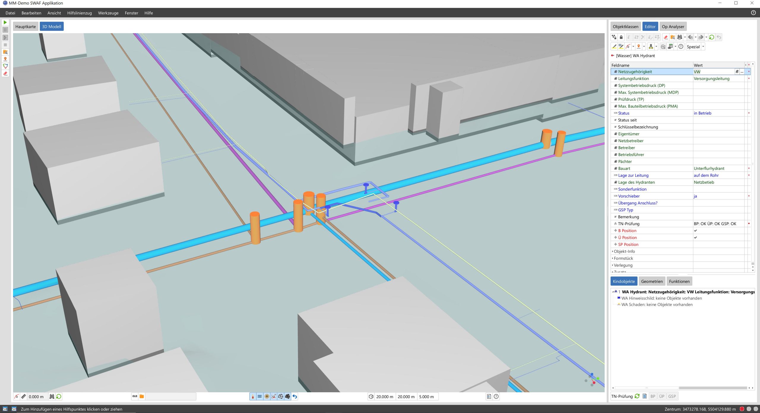
Networks in 3D: With the new multi-utility 3D network model, the GIS gains a new perspective on the networks and their assets.
Switching to Smallworld GIS is worthwhile
More and more network operators are opting to switch to the Smallworld GIS with the standard sector modules (NRM). From small municipal utilities to supra-regional network operators, the system covers all technical requirements and offers investment security both for the continuously maintained network database and for the IT landscape as a whole. High-quality and comprehensive network data in accordance with DVGW GW 130/VDE-AR-N 4205 is a key factor for success in core network processes. It provides guidance and forms the basis for network planning and network compatibility assessments, for maintenance processes, during fault clearance, and through integration with business systems.